LiDAR Laser Surveying
learn moreAdvanced light detection and ranging (LiDAR) land surveys offer numerous advantages over other techniques.
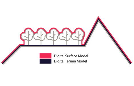
Also known as laser scanning, this technology provides extremely precise control and visualisation through dense point clouds. With cutting-edge drone technology, LiDAR enables laser pulses to penetrate dense vegetation in order to reach the ground surface. This technology is ideal for terrain modelling, works perfectly in low-light conditions, and offers a distinct advantage over photogrammetry. While photogrammetry can deliver a reconstructed digital surface model (DSM), only LiDAR can deliver accurate and survey-grade DSMs and digital terrain models (DSM).
Our use of UAS (unmanned aerial systems) with LiDAR enables highly accurate terrestrial surveying, land surveying, and topographical mapping among other services. Ideal for easement assessments or land surveying, laser scanning is the fastest and most affordable way to survey difficult terrain. We can deliver terrain data in a number of practical formats, including LAS/LAZ laser point clouds, 3D models, DXF/DWG vector files, ground contours, TIN, etc.
Measure Australia is one of the only companies in Australia to offer this cutting-edge service.

Advanced laser technology
Not all LiDAR systems are created equally, with precision hardware needed to create high-resolution models. Our laser scanning systems operate at upwards of 1,500,000 points per second and have a point density of 600-800 points per square metre in 3D form. This technology is cost-effective and highly practical for a range of applications, from small house and land surveys through to large mining, power, and environmental projects that stretch across tens of thousands of kilometres.
LiDAR data is similar in many ways to land survey information, only it’s much more accurate and often more than 10 times cheaper than having a manned surveyor on-site.
Data transformation and output
The information collected with LiDAR is only useful when it’s translated and presented in a clear and concise fashion. Inaccuracy in LiDAR is reliant heavily on processing skills and expertise. We leverage leading software solutions based on machine learning and artificial intelligence and provide access to an output portal for all captured data. All data is processed using best-practice methodologies, by in-house staff experienced on hundreds of projects just like yours. Whether you’re a survey company looking to access difficult terrain or a private company who needs accurate and affordable land-based data, Measure Australia is here to help.